Contents
Index
Program Settings
This option is found in the File Menu by selecting Settings and then Program Settings.
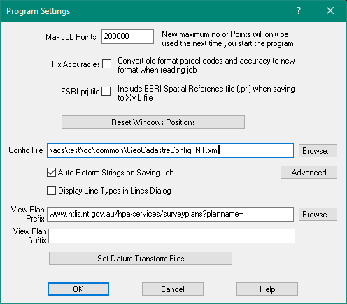
Max Job Points
This option will allow you to specify the maximum number of points for future jobs.
The amount of memory allocated by the program for storage of points is directly affected by the maximum number of points allocated here.
The maximum number of points that the program will allow to be set here is 1 million.
Any value up to 1 million can be set as the maximum number of points which then allows the program to
set this value as the largest point number that can be used in the job.
Even if there are unused point ranges in the job, no point number in the job can be larger than the
number that is set here.
Important: The value the user sets here, will only be used the next time that GeoCadastre is
started. To activate this new maximum number of points, the current job must be saved, the user must exit out of GeoCadastre (after setting the new maximum point value), and then GeoCadastre must be restarted.
Note: While very large jobs can be built and held in Geocadastre, there is a limit to
the number of parcels that can be processed by the Adjustment.
In practical terms, it is not advisable to process more than 2000 parcels in a job.
For more details regarding size limitations see Adjust Job
Enlarging a Job
When you run out of points, do the following.
1. Save the job.
2. Set the Maximum Point Number in Program Settings to a higher value.
3. Stop GeoCadastre
4. Re-start GeoCadastre and open the job. You can now use up to the new maximum point number.
Fix Accuracies
This option allows the user to convert old format parcel codes and accuracies to new format.
This processing is done when a job is read into GeoCadastre.
It should only be used when reading in an old file in the DOS format.
See Old Format Data
When reading Old format file, the rules are as follows:
Compiled plans are set to accuracy 5 if no accuracy is specified.
Type 16 parcels are set to Compiled and the accuracy to 5 if no accuracy is specified.
Type 17 parcels are set to Compiled and the accuracy to 6 if no accuracy is specified.
Type 16 & 17 parcels have their type set to 0.
Type 2000-2999 parcels force (override) the accuracy to 1, type reduced to 0-999 range.
Type 3000-3999 parcels force (override) the accuracy to 2, type reduced to 0-999 range.
Type 4000-4999 parcels force (override) the accuracy to 3, type reduced to 0-999 range.
Type 5000-5999 parcels force (override) the accuracy to 4, type reduced to 0-999 range.
Type 6000-6999 parcels force (override) the accuracy to 5, type reduced to 0-999 range.
Type 8000-8999 parcels force (override) the accuracy to 6, type reduced to 0-999 range.
Any parcel lines with accuracy outside the range 1-6 is set to the parcel accuracy, except
parcels with type 995 are set to 1.
Compiled parcels with type 997 or 999 take a line accuracy from the date or the Compiled/16/17 checking above.
ESRI prj file
This option is used when exporting the data as an XML file for the ESRI cadastral editor system.
If this is selected, on export the system will prompt to browse for a geodetic datum/projection file to be
included in the output.
Reset Window Positions.
The locations of dialog boxes are “remembered” by holding them in the computer registry.
This allows them to appear in the same position on the screen if the program is closed and restarted.
If however, a dialogue box is moved completely off a screen, there is no obvious way of getting it back.
This can happen if you move from a two screen system to a single screen system.
This button will re-set all the screen positions back to standard locations for a single screen configuration.
Config File
This can be used to define additional menu items for Plans, Parcels and Parcel lines.
These items are then stored as “Extra Attributes” to the object.
The Config File MUST be set in the Program Files for the program to be able to run.
When purchasing GeoCadastre, you would have been supplied with a standard Config File, browse to the location of this file.
Note: This Config File is read when the program starts, so if you are editing the file to make changes,
you must re-start the program before the changes will take effect.
An example of part of a config file is shown below. It adds an extra column to the data entry grid
for parcel lines to record the option “Mk Purpose” .
The element in the grid will be a combo box which will display seven options and store the option as an
extended arttribute called “MkPurpose”.
<config>
<gridConfig>
<name>NSW LTO</name>
<defineColumn>
<columnNumber>7</columnNumber>
<heading>MkPurpose</heading>
<extendedAttribute>
<name>MkPurpose</name>
<value></value>
<type>VT_I4</type>
</extendedAttribute>
<editType>ComboBox</editType>
<defaultEntry>6</defaultEntry>
<editEntries>
<entry>Azimuth/Datum</entry>
<entry>Boundary</entry>
<entry>Reference</entry>
<entry>Survey Control</entry>
<entry>Traverse</entry>
<entry>Witness</entry>
<entry></entry>
</editEntries>
</defineColumn>
Auto Reform Strings on Saving Job
This option, when selected, will automatically reform all the strings in the current job each time
that the job is saved.
Display Line Types in Lines Dialog
Tick this box to display the Line Type descriptions in the Lines dialog box.
The Line types depends on the definitions in the config file.
Click here for more info.
View Plan Prefix - Suffix
This option allows you to view the jpg or pdf file for the plan.
Prefix - Select the folder for the plan jpg or pdf files
Suffix - enter the correct file extension ".jpg" or ".pdf" or ".png" or ".tif"
It takes the Prefix + Plan_name + Suffix to compose the file name required.
Prefix = "c:\temp\"
Plan_name = "DP123456"
Suffix = ".pdf"
File name to be opened = "c:\temp\DP123456.pdf"
To View the Plan
Right click on the Parcel Explorer parcel to choose View Plan PDF
GeoCadastre will start a pdf viewer or jpg viewer to display the plan file.
or, Select a parcel, then right click the parcel, choose View Plan PDF
or, In Parcel Editor, Misc menu, View Plan PDF
Click here for more info.
Set Transform Files
You can set the GSB (NTv2) transform files which will be used in the conversion from one datum to another.
Note: If you are converting from AGD1966 to GDA2020, two conversions will be done
AGD1996 to GDA1994 and then GDA1994 to GDA2020.
Click here for info.